How to Georeference K5 Raster Maps from the Berlin Senat in QGis

I was lucky enough to get a present from the wonderfully generous Teri Rueb when she was in Berlin making an mscape project (those were the days) at the Akademie der Künste. Even though it’s out-of-date, I still like the funky old-fashioned state raster of Berlin with every apartment block numbered. Here’s the unhelpful page from the Berlin state: https://www.stadtentwicklung.berlin.de/service/veroeffentlichungen/de/karten/digital/extra/k5rd.shtml as an explanation why this explanation is necessary.

  1. I have halved the dimensions of the tiffs included on the CD and saved as gifs, but the process should be the same for the full size tiffs. Make sure you have the ‘uebersicht-K5’ image to refer to. This is your data source for georeferencing.
  2. Make sure you have the georeferencer plugin installed and enabled. Info here: https://gis-lab.info/qa/qgis-georef-new-eng.html
  3. Start a new project in QGis with ‘DHDN / Soldner Berlin – EPSG:3068’ as the Coordinate Reference system (CRS). You’ll find it in ‘Projected Coordinate Systems/Cassini’ or just search for the name
  4. Start the plugin (Plugins/Georeferencer) and click File/Open Raster (ctl+O)
  5. Browse to the image file from the Senat. This loads it into the big window in the georeferencer
  6. Zoom and pan to the top right-hand corner of the image and click Add Point
  7. Click as near as you can to the top-right hand corner (you can adjust later). A dialogue box comes up for you to enter the coordinates in.
  8. Find your image on the uebersicht image and read off the x coordinate of the left edge of the image e.g. 413B is x=24000. Repeat for top edge e.g. 413B:y=19600. Click OK
  9. The bottom pane now has the details of this point and this is where you can adjust. As this is the top left hand corner, the srcX and srcY values should be 0. If they aren’t, you can adjust them by clicking in the cell and typing them in. Use ‘Enter’ on the keyboard, not ‘Tab’ to make sure your changes stay (don’t know why and might change)
  10. Go to the bottom right hand corner and repeat the process. For 413B the values are x:27200, y:17200. Again, you might have to adjust the srcX and srcY values to whole numbers to make sure the point is really at the bottom right hand corner.
  11. You have enough information to include one more point. I choose the bottom left hand corner. Using a mixture of the coordinates already entered, you should be able to enter this without too much fuss.
  12. If you click the green triangle now (Start Georeferencing), a transformation settings dialogue box might come up. Leave Linear transformation and resampling on, no compression. Now comes the unintuitive bit: I want to leave my gif where it is and only create a world map but if you click world map, it asks for an output file name and the box is greyed out. The way around this is to first pretend you will produce a new image file by unselecting ‘Create World File’, enter the name of the file you already have loaded (pretend it is going to be a tiff), say ok to the file browser and then select ‘Create World File’. The georeferencer will then not complain about not knowing what to call the world file.
  13. Congratulations. You’ve done all that work but there’s still no raster file in QGis? Actually you’ve done something quite powerful and created a world file for that image no matter what Qgis you’re in. You should never have to georeference that raster again, unless you want to transform the image to another coordinate system (which is really what the georeferencer is all about). All you have to do is click Add Raster Layer, navigate to the IMAGE file you referenced (a .gif in my case) and say ok. Qgis will find the associated .wld file and pop it in.
  14. One last thing. Qgis might import new layers with something other than the project CRS, in which case, you have to double click on the layer you just added or right click/Properties and make sure, under the ‘General’ tab, that ‘EPSG:3068 – DHDN / Soldner Berlin’ is in the Coordinate reference system box.
  15. That’s it. Not very straightforward, but at least once you’ve done it for one project and you save the .wld file alongside the image file, you shouldn’t ever have to do it again.

Posted in Linux | Tagged , , , | Comments Off on How to Georeference K5 Raster Maps from the Berlin Senat in QGis

Hooray for Distributed Version Control. Boo for Dropbox

I’ve been having problems with Dropbox lately, not updating all files. I still haven’t got to the bottom of that but last night I worked on a Python script down our studio and wanted to polish it up at home but hey presto! It wasn’t there in the Dropbox – just the old version I’d renamed. Now it could be a problem with using Mercurial and Dropbox like I did (details follow) but I think that this morning I’ve solved it, thanks to this post.

What I used to do: Python scripts in the Dropbox under version control with Mercurial.
Now: I have my scripts locally and push/pull to a Mercurial repository only in the Dropbox. This means that there are no actual scripts in the Dropbox, just the magic .hg files from which you can clone everything.

The happy ending was that after creating an independent clone of my python scripts from the Dropbox folder (using the hg clone --pull option), my script from last night was all there, just as it should be.
Lesson learned.

Posted in Code, Diary, Linux, Software | Tagged , | Comments Off on Hooray for Distributed Version Control. Boo for Dropbox

Digital Dowsing 0.1

It’s been around enough in my mind (actually since the Suffolk Psychogeophysics Summit [SPS]) to finally talk about it here. A mash-up of the esoteric and the technological – my nascent Digital Dowsing project.

My dowsing weapons of choice are two pieces of brass rod, bent at right-angles, held loosely in the hands. With me, they cross each other when I’m over something. I’m not so concerned with what it is that triggers them and I’m not so interested in the esoteric theories of how they work but it does seem to me that they are indicators of some subconscious impulse that most people have to fine-grained location. I also have experienced casual evidence of ‘agreement’ between people. This happened at the SPS when Ryan took them and seemed to find similar ‘findings’ as me. This happened again during Martin’s workshop in Tiergarten where an adult and his 6-year-old daughter had a go with the rods and seemed to find places that agreed with my findings.

What I want to do is build a(n Arduino?) datalogger that, in conjunction with an accurate, industry standard GPS (more of this in a future post), would log the movement of the rods and geolocate them on a map, enabling the results to be compared either between users or allow one user to build up a dowsing landscape over a certain area.

Perhaps unsurprisingly, I am not the first. Don’t put ‘Digital Dowsing’ into Google, that way lies madness. Here are some projects I found interesting

  • Here is someone who has given it a go on archaeological sites in England. Seems to be using the rod technique but frustratingly little technical detail.
  • This project from ISEA2008 in Singapore also seems very interesting. Uses the split stick method and an accelerometer. Elegant. But guys – is that datalogger really ‘small’? How accurate is that fob-style GPS around your neck?

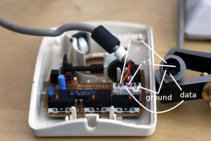
My DD0.1 is to use the brass rods and try to digitise their movement with rotary encoder found in an old mouse. This seems better to me than the potentiometer method of rotary encoding which would put too much stiffness in the swing of the rods.

In my initial searches for hacking the mouse itself, I came across this excellent site as well as a page on the Arduino Playground site itself about interfacing a PS/2 mouse with an arduino.

Here’s a nicely annotated photo mostly for my own reference and hopefully anyone else out there who might need it:

Logitech Mouse Annotated

What the wires are on a Logitech Trackball PS/2 Mouse

Posted in Diary, GPS, Linux, Walking | Tagged , , | 3 Comments

You’re the product, not the customer

Mathieu also pointed me towards this pertinent summation of Facebook, Google & Co:

If you are not paying for it, you’re not the customer; you’re the product being sold.

blue_beetle, you said it very well.

Posted in Diary, Software | Tagged | Comments Off on You’re the product, not the customer

Memory Palace Operating System

A very inspiring talk tonight in Neukölln with Mathieu Baudier. He was talking about his vision for a file browser where instead of some hierarchical structure on the left hand panel (or in the case of mac, some shortcuts) and a list of files in the main panel, the left panel would be a zoomable map which would also have a time slider and all content would be geographically and temporally searchable in the browser. We talked about how natural it was for humans to remember things in a landscape and of memory palaces and how we are not just users of our operating systems, but being trained by them (what a horrific thought, especially, unfortunately for Windows users but Mac users are not free of this orthodoxy). How computers operating systems are not yet working hard enough for us, how they force us into the crummy paradigm patched together in the 70s by computer scientists when we should be forcing them into OUR paradigm of landscape, interaction, embodied space.

Come on Linux people – let’s do it!

Posted in Diary, Linux, Software | Tagged | Comments Off on Memory Palace Operating System